Ride
Intermediate
Steady, with some endurance
Lake Casa de Campo - Cerro de los Ángeles

Organized by the group
Madrid · Zona Centro | MTB | Intermedio
Madrid
Bike
MTB · E-MTB +1
Distance
27.6 km
Elevation
183 m
Duration
4h
Meeting point
Madrid
View route
Lago Casa de Campo/ Cerro de los Ángeles
📍 SalidaIniciamos la ruta desde un kiosko situado frente al restaurante El Urogallo Casa de Campo y nos incorporaremos a Madrid Río, recorriendo su carril bici. Si alguien desea que le recojamos en algún punto intermedio de Madrid Río, que nos lo comunique.🌳 Pasaremos por el Parque Lineal del Manzanares y, una vez que dejemos atrás el parque y el río Manzanares, tomaremos una vía ciclista en la que ya no encontraremos sombra arbolada. Si se prevé un día de calor, se recomienda llevar suficiente agua, aunque nos encontraremos con fuentes.⛪ Continuaremos hacia el desvío del Cerro de los Ángeles, en Getafe. Se trata de una pequeña ascensión, breve pero especial, por situarse —o al menos así se ha considerado durante muchos años— en el centro geográfico de la Península Ibérica. Las laderas del cerro están repobladas de pinos carrascos, aportando un entorno natural y verde.⛰️ La subida, desde la entrada al recinto hasta la cima, tiene unos 1,2 kilómetros, con un desnivel acumulado de 57 metros y una pendiente media del 4,75%. Se pueden encontrar rampas entre un 7% y un 10%. Quien no desee subir al cerro podrá quedarse en la entrada del recinto, donde esperará al grupo, que regresará posteriormente para realizar la vuelta todos juntos.📸 En la explanada de la cima se encuentran la ermita de Nuestra Señora de los Ángeles (siglo XIV), patrona de Getafe, y el Monumento al Sagrado Corazón de Jesús, inaugurado en 1919 por Alfonso XIII, además de otros edificios y espacios religiosos que forman parte del Santuario del Cerro de los Ángeles. Desde arriba disfrutaremos de amplias vistas del sur de Madrid.🍌💧 Cada uno subirá al ritmo que necesite, y nos esperaremos arriba para realizar el tentempié y un pequeño descanso. 🚲 A nivel técnico, la ruta no presenta dificultad, ya que discurre casi en su totalidad por carril bici. La única exigencia será tener una condición física adecuada para completar los 45 kilómetros y afrontar el esfuerzo extra de la subida al cerro para quienes decidan realizarla.👥 El ritmo lo marcará siempre el miembro más lento. Aunque la ruta no es complicada y es muy transitada, pedimos que no se deje solo al último del grupo. Quien quiera ir más rápido podrá hacerlo, aunque recomendamos circular en parejas o pequeños grupos, acordando previamente puntos de parada para reagruparse.📍 Puntos de reagrupamiento Estos puntos coinciden con los desvíos más importantes de la ruta, donde, si no se conoce la zona o no se lleva descargado el track, es más fácil pasarse los cruces o equivocarse de dirección:1️⃣ https://maps.app.goo.gl/sHFiSyWhiMxKpfbB8?g_st=aw2️⃣ https://maps.app.goo.gl/QXJtjLYALJCn59vq8?g_st=aw📲 Recomendamos que cada participante descargue su track, por si fuese necesario consultarlo en cualquier momento.⚠️ Ni el organizador ni ningún miembro del grupo se hacen responsables de cualquier incidente o imprevisto, siendo cada participante responsable de sí mismo en todo momento.☀️ Será una ruta para disfrutar del recorrido, compartir kilómetros y pasar una buena mañana en bici.
About this ride
📍 Exit
We start the route from a kiosk located in front of the El Urogallo Casa de Campo restaurant and we will join Madrid Río, traveling along its bike path.
If anyone would like us to pick them up at any point along Madrid Río, please let us know.
🌳 We will pass through the Manzanares Linear Park and, once we leave the park and the Manzanares River behind, we will take a cycle path where we will no longer find shade from trees.
If a hot day is expected, it is recommended to bring plenty of water, although we will find fountains.
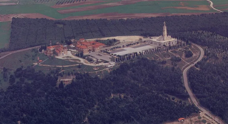
⛪ We will continue towards the turnoff for Cerro de los Ángeles, in Getafe. It is a short but special climb, as it is located—or at least has been considered for many years—in the geographical center of the Iberian Peninsula. The slopes of the hill are reforested with Aleppo pines, providing a natural and green environment.
⛰️ The climb, from the entrance to the grounds to the summit, is approximately 1.2 kilometers long, with a total elevation gain of 57 meters and an average gradient of 4.75%. There are sections with gradients between 7% and 10%. Those who do not wish to climb the hill can remain at the entrance to the grounds, where they will wait for the group, which will return later to complete the loop together.
📸 On the summit esplanade are the Hermitage of Our Lady of the Angels (14th century), patron saint of Getafe, and the Monument to the Sacred Heart of Jesus, inaugurated in 1919 by Alfonso XIII, as well as other religious buildings and spaces that form part of the Sanctuary of Cerro de los Ángeles. From the top, we will enjoy sweeping views of southern Madrid.
🍌💧 Everyone will climb at their own pace, and we'll wait for each other at the top for a snack and a short break.
🚲 Technically, the route is not difficult, as it runs almost entirely on a bike path. The only requirement is having adequate physical fitness to complete the 45 kilometers and handle the extra effort of the climb up the hill for those who decide to do it.
👥 The pace will always be set by the slowest member. Although the route is not difficult and is well-trodden, we ask that you do not leave the last person in the group alone. Anyone who wants to go faster may do so, although we recommend riding in pairs or small groups, agreeing on stopping points beforehand to regroup.
📍 Regrouping points These points coincide with the most important detours of the route, where, if you don't know the area or haven't downloaded the track, it's easier to miss the turns or go the wrong way:
1️⃣ https://maps.app.goo.gl/sHFiSyWhiMxKpfbB8?g_st=aw
2️⃣ https://maps.app.goo.gl/QXJtjLYALJCn59vq8?g_st=aw
📲 We recommend that each participant download their track, in case it is necessary to consult it at any time.
⚠️ Neither the organizer nor any member of the group is responsible for any incident or unforeseen event, each participant being responsible for themselves at all times.
☀️ It will be a route to enjoy the journey, share kilometers and spend a good morning on a bike.
Organized by
Yolanda
4 signed up
Sign in to see who has signed up
Photos
Galería de fotos
1 / 10